An Archaeologist Uses
Kite Aerial Photography
Bruce Owen
Sonoma State UniversityMay 2006
Click any image for a larger version.

This is a small part of the site of Pillistay, in the Camaná valley of the far south coast of Peru.
It may date between 500 and 1000 AD, but we won't really know until we excavate there this summer.
From the ground, it is hard to grasp the overall plan.
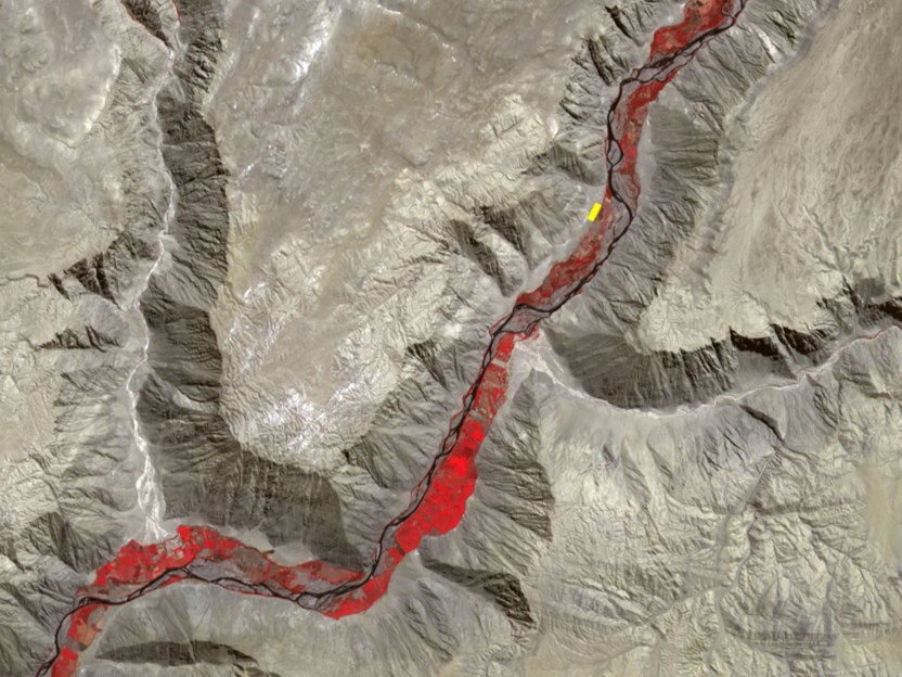
Widely available satellite photos, like this ASTER image from the Terra satellite,
have pixels 15 meters across. The entire site of Pillistay fits in the yellow blob.
This gives a great view of the setting, but is useless for the architecture.

Air photos taken for topographic mapping are much better, but still a bit fuzzy.
This is a 600 dpi scan of a high-quality contact print, with tones optimized to bring out the walls.
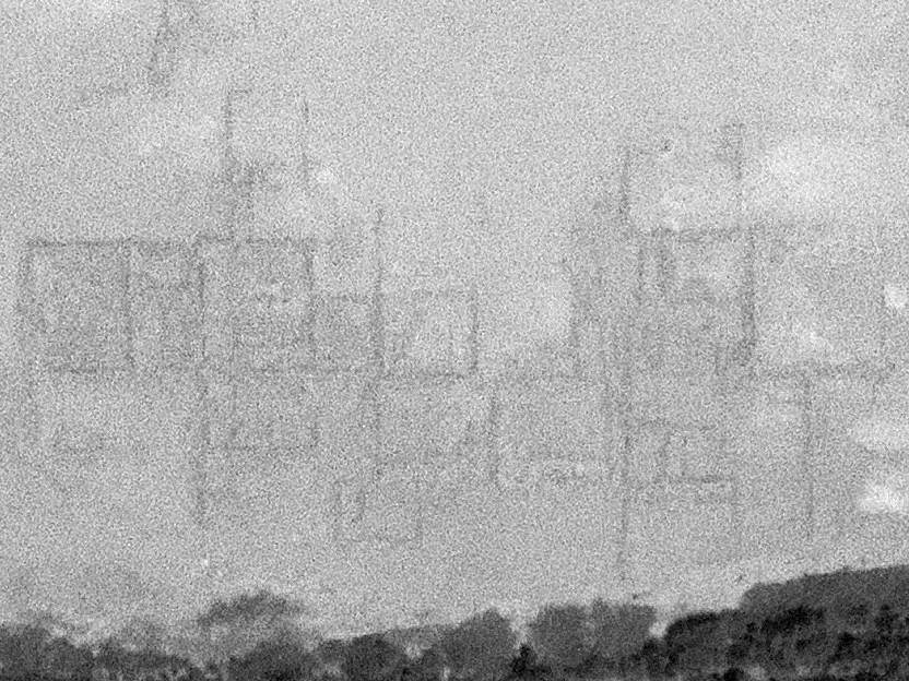
Expensive, very high resolution drum scans of the air photo negatives are little help.
They just give a sharper view of the grains in the film.
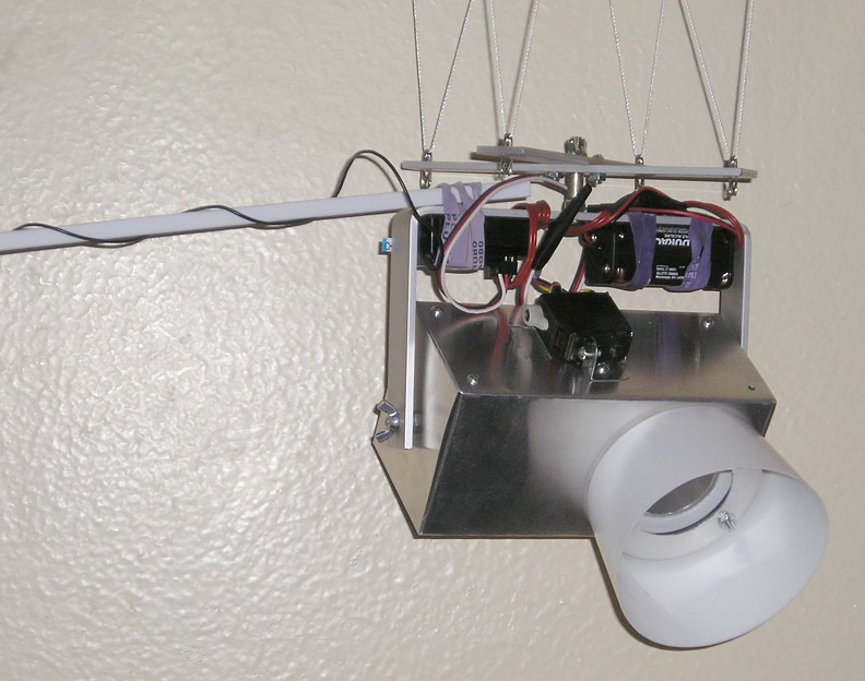
This contraption allows me to do better. It is a Kite Aerial Photography (KAP) rig.
It completely encloses a 4 megapixel Olympus D-580 point-and-shoot digital camera.
The sun shade is also a shock absorber.
A servo motor for radio-controlled airplanes presses the button to take a picture.
It is simpler and more rugged than most KAP rigs, in order to survive dusty, sandy conditions
and occasional crashes on rocky ground.

The KAP rig hangs from the string that is held aloft by this Sutton Flowform 16 kite.
The kite is about four feet by four feet, and is stabilized by a compact drogue tail.
Photo: Merryl Owen

The KAP rig is stabilized by a cross-shaped device called a Picavet, with a long string that loops
through a smooth eye on each arm and rings connected to the kite line at two points.
This arrangement automatically tends to level the KAP rig,
compensating for the changing angle of the kite line.
Photo: Gabriel Prieto, Proyecto San José de Moro
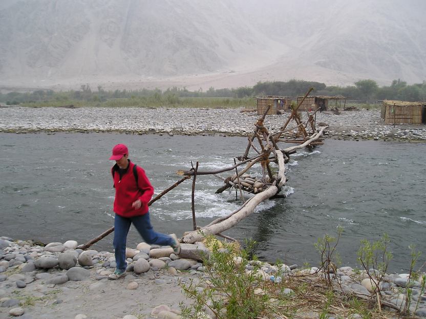
Why use a kite? Consider some alternatives.
A balloon would require hauling a tank of gas across this bridge and a mile upriver to Pillistay.
To get to other sites, we ford the river, which is thigh-deep and has a strong current.
Carrying a tank of gas or an inflated balloon does not appeal.
Buying or refilling tanks in rural Peru would also be a problem.
Finally, a balloon would carry the camera away if it got loose.
A remote-controlled airplane or helicopter would be more expensive, fragile, and bulky,
and probably could not handle the frequently high winds and gritty environment.
Flying a manned aircraft low in the deep, narrow, windy valley would be suicidal.
KAP equipment is small, light, cheap, and tolerant of high winds.
However, there must be a decent wind and suitable places to stand for the desired shots.
Does KAP work? Not always. Lots of shots are blurred due to camera motion.
This example is from a trial at Halfmoon Bay.

With a digital camera and a large memory card, I can just snap eight or ten tries for each shot,
pick the sharpest one, and chuck the rest.
This is a better example from the trial at Halfmoon Bay.

For a larger view, I combine multiple shots in a montage.
This is my first, somewhat crude attempt, using some shots from Halfmoon Bay.
The actual montage is much higher resolution than is shown here.
In this test, I learned that it is hard for the kite flier to estimate how far away the camera is.
The montage shows that it was much further from me than I thought at the time.

I combine the best images using Hugin, an extraordinary public domain graphical interface program
for the equally remarkable Panotools montaging software, both downloadable from Sourceforge.net.
This software combination can handle images in any mix of orientations and scales
(since the camera rotates a bit and the kite rises and falls with the wind),
and can even correct lens distortions and exposure variations.
With better-behaved images, it can match the shots automatically.
With KAP shots, I have to manually pick matching points in overlapping images.
Hugin helps by optionally "fine-tuning" the points once I get them close.
To reduce distortion, I place straight lines of markers at 25 meter intervals across the site.
Hugin can make the markers fall along vertical and/or horizontal lines in the output montage.

The entire setup fits easily in a day pack, with room for lunch.
The orange stuffsack in the foreground holds the kite.
The small black case just behind it holds the camera. The blue hoop holds 500 feet of 200 lb. kite line.
The case in front of me holds the KAP rig and remote control.
The cross-shaped piece on the kite sack is the Picavet.
Photo: Henry Tantaleán

This is a single KAP image of Pillistay. Note Henry Tantaleán and his shadow in the upper left quadrant.
Henry has the remote control. I have the kite string.
Henry is guiding me by pocket radio to position the kite more or less above him by changing where I stand.
He clicks six or eight shots, then paces off a set distance to his next station.
The entire process, including laying out and removing the control points, takes less than half a day in the field,
far faster than even the crudest of sketch mapping.
The computer work afterwards, however, is very time consuming.
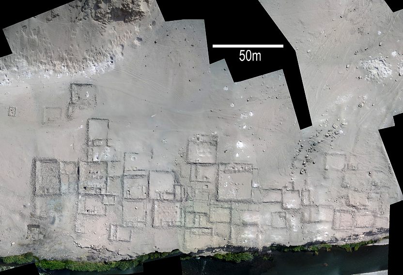
This a very reduced version of the completed montage of Pillistay.
The site is probably more rectilinear than this slightly distorted montage suggests.
I used only one vertical and one horizontal line of control points, which do not fully constrain the montage.
This montage and those of two other sites will guide us in making accurate, electronically surveyed maps.
We will then correct the KAP montages by "rubber sheeting" them to fit the maps, using GIS software.
Together, the accurate topographic maps and the corrected KAP montages will document the sites.
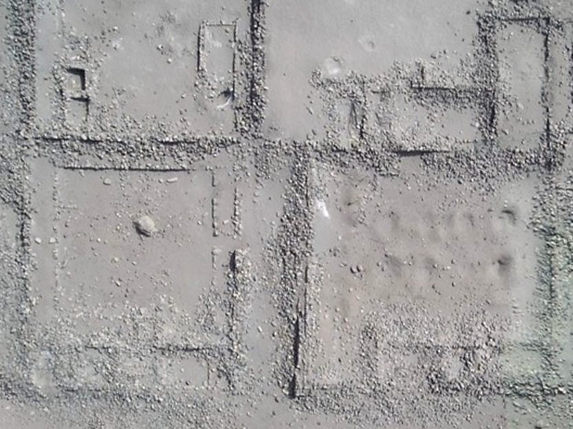
This detail from the montage of Pillistay gives an idea of the high resolution possible.
The image above is scaled down by 50% from the final montage. Click on it to see it at full resolution.
The images were already reduced to one-third of their original resolution to speed the montaging process.
This quality of stone-by-stone recording of a large archaeological site would be
difficult and expensive to achieve without KAP.
For more information about KAP, see
KAP E-Resources, by David Hunt
Thanks to
Sonoma State University School of Social Sciences, for summer grants in 2004 & 2005National Science Foundation, for funding the upcoming 2006 season
Al Wahrhaftig, for donating radio control equipment and sharing his knowledge of radio controlled aircraft
Luis Jaime Castillo, for Moro project collaboration (not shown here)
Santiago Uceda, for Moche Zona Urbana project collaboration (not shown here)
Henry Tantaleán, Peruvian director of the 2006 Camaná project, for tireless fieldwork
Merryl Martin Owen, for testing, fieldwork help, and action photos
Gabriel Prieto, for action photos at San José de Moro
Nico Tripcevich, for access to Terra ASTER satellite photos
David Hunt, for the invaluable KAP E-Resources website http://www.kaper.us
An Archaeologist Uses Kite Aerial Photography by Bruce Owen
Copyright (c) 2006, Bruce Owen. All rights reserved.
Please send comments on content and presentation to
Dr. Bruce Owen.
URL of this document: http://bruceowen.com/kap/kap.htm
Revised: 21 May 2006